
Guarulhos topographic map
Click on the map to display elevation.
About this map
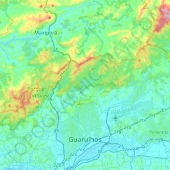
Name: Guarulhos topographic map, elevation, terrain.
Average elevation: 2,759 ft
Minimum elevation: 2,356 ft
Maximum elevation: 4,636 ft
Other topographic maps
Click on a map to view its topography, its elevation and its terrain.
São Paulo
Brazil > São Paulo > Região Metropolitana de São Paulo
The city is on a plateau placed beyond the Serra do Mar (Portuguese for "Sea Range" or "Coastal Range"), itself a component of the vast region known as the Brazilian Highlands, with an average elevation of around 799 meters (2,621 ft) above sea level, although being at a distance of only about 70 kilometers…
Average elevation: 2,575 ft