
Odesa topographic map
Click on the map to display elevation.
Odesa
Odesa is situated (46°28′N 30°44′E / 46.467°N 30.733°E / 46.467; 30.733) on terraced hills overlooking a small harbor on the Black Sea in the Gulf of Odesa, approximately 31 km (19 mi) north of the estuary of the Dniester river and some 443 km (275 mi) south of the Ukrainian capital Kyiv. The average elevation at which the city is located is around 50 metres (160 feet). The maximum is 65 metres (213 feet) and minimum (on the coast) amounts to 4.2 metres (13.8 feet) above sea level. The city currently covers a territory of 162.42 km2 (63 sq mi).
About this map
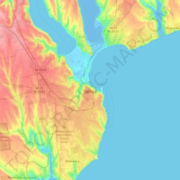
Name: Odesa topographic map, elevation, terrain.
Location: Odesa, Odesa Urban Hromada, Odesa Raion, Odesa Oblast, Ukraine (46.34267 30.61140 46.62912 30.83138)
Average elevation: 85 ft
Minimum elevation: -26 ft
Maximum elevation: 272 ft
Other topographic maps
Click on a map to view its topography, its elevation and its terrain.
Izmail
Under the Köppen climate classification, Izmail falls within either a hot-summer humid continental climate (Dfa) if the 0 °C (32 °F) isotherm is used or a humid subtropical climate (Cfa) if the −3 °C (27 °F) isotherm is used. Izmail experiences four distinct seasons and generous precipitation…
Average elevation: 62 ft