
Izmail topographic map
Click on the map to display elevation.
Izmail
Under the Köppen climate classification, Izmail falls within either a hot-summer humid continental climate (Dfa) if the 0 °C (32 °F) isotherm is used or a humid subtropical climate (Cfa) if the −3 °C (27 °F) isotherm is used. Izmail experiences four distinct seasons and generous precipitation year-round, typical for the inland South. Summers are hot and humid, with temperatures somewhat moderated by the city's elevation. Winters are cool but variable, with an average of 48 freezing days per year.
About this map
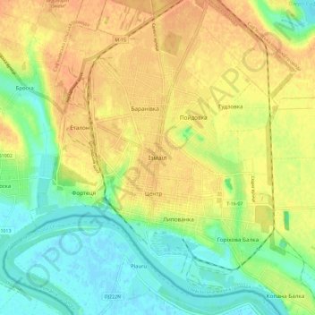
Name: Izmail topographic map, elevation, terrain.
Average elevation: 62 ft
Minimum elevation: -7 ft
Maximum elevation: 118 ft
Other topographic maps
Click on a map to view its topography, its elevation and its terrain.
Odesa
Odesa is situated (46°28′N 30°44′E / 46.467°N 30.733°E / 46.467; 30.733) on terraced hills overlooking a small harbor on the Black Sea in the Gulf of Odesa, approximately 31 km (19 mi) north of the estuary of the Dniester river and some 443 km (275 mi) south of the Ukrainian capital Kyiv. The…
Average elevation: 85 ft
Odesa
The city is situated on terraced hills overlooking a small harbor. The average elevation at which the city is located is around 50 metres (160 feet). The maximum is 65 metres (213 feet) and minimum (on the coast) amounts to 4.2 metres (13.8 feet) above sea level. There are three large estuaries near the city:…
Average elevation: 85 ft
Izmail
Under the Köppen climate classification, Izmail falls within either a hot-summer humid continental climate (Dfa) if the 0 °C (32 °F) isotherm is used or a humid subtropical climate (Cfa) if the −3 °C (27 °F) isotherm is used. Izmail experiences four distinct seasons and generous precipitation…
Average elevation: 59 ft
Odesa
The city is situated on terraced hills overlooking a small harbor. The average elevation at which the city is located is around 50 metres (160 feet). The maximum is 65 metres (213 feet) and minimum (on the coast) amounts to 4.2 metres (13.8 feet) above sea level. There are three large estuaries near the city:…
Average elevation: 85 ft
Odesa
Odesa is situated (46°28′N 30°44′E / 46.467°N 30.733°E / 46.467; 30.733) on terraced hills overlooking a small harbor on the Black Sea in the Gulf of Odesa, approximately 31 km (19 mi) north of the estuary of the Dniester river and some 443 km (275 mi) south of the Ukrainian capital Kyiv. The…
Average elevation: 85 ft