
Thank you for supporting this site ❤️
Make a donation
Make a donation
Gear up for your next adventure:
As an Amazon Associate, this site earns from qualifying purchases at no extra cost to you.
Pucará topographic map
Click on the map to display elevation.
Thank you for supporting this site ❤️
Make a donation
Make a donation
Gear up for your next adventure:
As an Amazon Associate, this site earns from qualifying purchases at no extra cost to you.
About this map
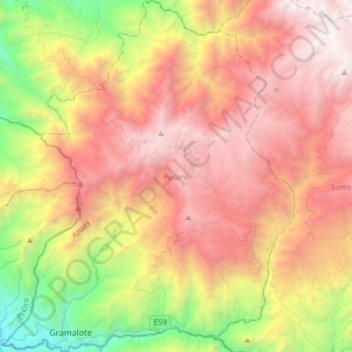
Name: Pucará topographic map, elevation, terrain.
Location: Pucará, Azuay, 010304, Ecuador (-3.32893 -79.66762 -3.02004 -79.41021)
Average elevation: 7,231 ft
Minimum elevation: 581 ft
Maximum elevation: 13,632 ft
Thank you for supporting this site ❤️
Make a donation
Make a donation
Gear up for your next adventure:
As an Amazon Associate, this site earns from qualifying purchases at no extra cost to you.