
Make a donation
Gear up for your next adventure:
As an Amazon Associate, this site earns from qualifying purchases at no extra cost to you.
Yumthang topographic map
Click on the map to display elevation.
Make a donation
Gear up for your next adventure:
As an Amazon Associate, this site earns from qualifying purchases at no extra cost to you.
About this map
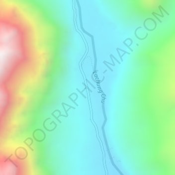
Name: Yumthang topographic map, elevation, terrain.
Location: Yumthang, Chungthang, Mangan, Sikkim, India (27.79426 88.69332 27.81426 88.71332)
Average elevation: 12,910 ft
Minimum elevation: 11,775 ft
Maximum elevation: 15,801 ft
Make a donation
Gear up for your next adventure:
As an Amazon Associate, this site earns from qualifying purchases at no extra cost to you.
Other topographic maps
Click on a map to view its topography, its elevation and its terrain.
Gurudongmar
India > Sikkim > Chungthang
Gurudongmar Lake is one of the highest lakes in the world and in India, at an elevation of 5,430 m (17,800 ft) according to the Government of Sikkim. It is located in the Great Himalayas in the Mangan District in Indian state of Sikkim, and considered sacred by Buddhists and Sikhs. The lake is named after…
Average elevation: 17,165 ft
Make a donation
Gear up for your next adventure:
As an Amazon Associate, this site earns from qualifying purchases at no extra cost to you.