Geolocate
👉 Easily get elevation data in JSON, GeoTIFF and KML formats using Elevation API
Thank you for supporting this site ❤️
Make a donation

Porcon topographic map

Click on the map to display elevation.

About this map

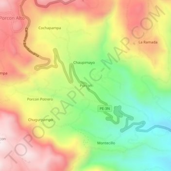
Name: Porcon topographic map, elevation, terrain.

Location: Porcon, Cajamarca, Perú (-7.10744 -78.60068 -7.06744 -78.56068)

Average elevation: 10,732 ft

Minimum elevation: 9,619 ft

Maximum elevation: 11,827 ft

Other topographic maps

Click on a map to view its topography, its elevation and its terrain.

Río Mashcón

Perú > Cajamarca > Cajamarca

Average elevation: 9,531 ft

Gear up for your next adventure:

🦟Ultrasonic Repellers - Create a bug-free zone at your camp or rest stop
🧭Pro Hiking Compasses - High-accuracy liquid-filled compasses for topographic orientation
🛠️Outdoor Gear Repair Kit - Essential tools to fix gear on the trail
🏥Hiking First Aid Kits - Comprehensive medical kits for remote trail injuries
📱Heavy-Duty Phone Cases - Drop-proof and waterproof protection for outdoor navigation

As an Amazon Associate, this site earns from qualifying purchases at no extra cost to you.