
Make a donation
Gear up for your next adventure:
As an Amazon Associate, this site earns from qualifying purchases at no extra cost to you.
Río Mashcón topographic map
Click on the map to display elevation.
Make a donation
Gear up for your next adventure:
As an Amazon Associate, this site earns from qualifying purchases at no extra cost to you.
About this map
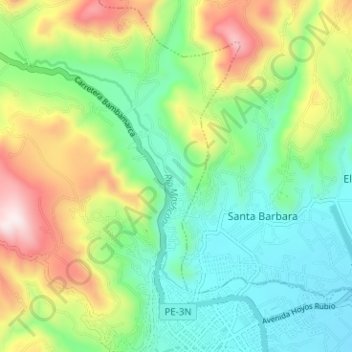
Name: Río Mashcón topographic map, elevation, terrain.
Location: Río Mashcón, Cajamarca, 06000, Perú (-7.14514 -78.55097 -7.10104 -78.48785)
Average elevation: 9,531 ft
Minimum elevation: 8,760 ft
Maximum elevation: 11,050 ft
Make a donation
Gear up for your next adventure:
As an Amazon Associate, this site earns from qualifying purchases at no extra cost to you.
Other topographic maps
Click on a map to view its topography, its elevation and its terrain.
Urb. Horacio Zeballos
Perú > Cajamarca > Cajamarca > Urb. Horacio Zeballos
Average elevation: 8,868 ft
Make a donation
Gear up for your next adventure:
As an Amazon Associate, this site earns from qualifying purchases at no extra cost to you.
Make a donation
Gear up for your next adventure:
As an Amazon Associate, this site earns from qualifying purchases at no extra cost to you.