
Mid-Western Development Region topographic map
Interactive map
Click on the map to display elevation.
About this map
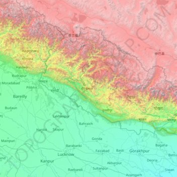
Name: Mid-Western Development Region topographic map, elevation, terrain.
Location: Mid-Western Development Region, Karnali Pradesh, Nepal (26.07861 79.12901 31.19861 84.24901)
Average elevation: 6,811 ft
Minimum elevation: 187 ft
Maximum elevation: 25,846 ft
Other topographic maps
Click on a map to view its topography, its elevation and its terrain.
Surkhet
Nepal > Mid-Western Development Region
Surkhet, Mid-Western Development Region, Karnali Pradesh, 21700, Nepal
Average elevation: 3,143 ft
Ghaghara River
Nepal > Mid-Western Development Region
Ghaghara River, Dailekh, Bheri, Mid-Western Development Region, 271833, Nepal
Average elevation: 4,993 ft
Mimi
Nepal > Mid-Western Development Region > Mimi
Mimi, Humla, Karnali, Mid-Western Development Region, Nepal
Average elevation: 14,245 ft