Geolocate

Chumuckla topographic map

Click on the map to display elevation.

About this map
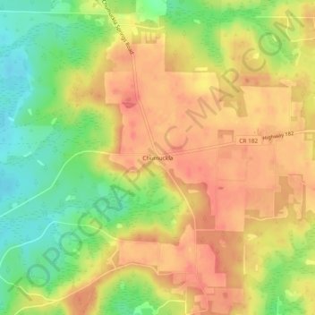
Name: Chumuckla topographic map, elevation, terrain.

Location: Chumuckla, Santa Rosa County, Florida, United States (30.75658 -87.25719 30.79658 -87.21719)

Average elevation: 161 ft

Minimum elevation: 43 ft

Maximum elevation: 243 ft

Other topographic maps

Click on a map to view its topography, its elevation and its terrain.
Pace

United States > Florida > Santa Rosa County > Pace

Average elevation: 56 ft

Milton

United States > Florida > Santa Rosa County

Average elevation: 49 ft

Gulf Breeze

United States > Florida > Santa Rosa County

Average elevation: 3 ft

Jay

United States > Florida > Santa Rosa County

Average elevation: 259 ft

Gulf Breeze

United States > Florida > Santa Rosa County

Average elevation: 3 ft

Milton

United States > Florida > Santa Rosa County

Average elevation: 49 ft

Gulf Breeze

United States > Florida > Santa Rosa County

Average elevation: 3 ft

Pace

United States > Florida > Santa Rosa County > Pace

Average elevation: 56 ft

Pace

United States > Florida > Santa Rosa County > Pace

Average elevation: 56 ft

Bagdad

United States > Florida > Santa Rosa County

Average elevation: 33 ft

Pace

United States > Florida > Santa Rosa County > Pace

Average elevation: 56 ft

Jay

United States > Florida > Santa Rosa County

Average elevation: 259 ft

Jay

United States > Florida > Santa Rosa County

Average elevation: 259 ft

Gear up for your next adventure:

🪑Ultralight Camp Chairs - Portable seating for resting after a long day of mapping
📡Handheld GPS Device - Reliable handheld GPS for outdoor navigation
🛰️Handheld GPS Units - Professional satellite navigators for precise backcountry mapping
🛏️Cold Weather Sleeping Bag - Warm sleeping bag for cold conditions
🥇GPS Hiking Watch - Multi‑sport GPS watch with navigation and trail tracking

As an Amazon Associate, this site earns from qualifying purchases at no extra cost to you.