Geolocate

Badrinath topographic map

Click on the map to display elevation.

About this map

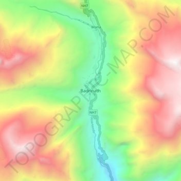
Name: Badrinath topographic map, elevation, terrain.

Location: Badrinath, Joshimath Tehsil, Chamoli, Uttarakhand, India (30.70233 79.45303 30.78233 79.53303)

Average elevation: 13,294 ft

Minimum elevation: 8,809 ft

Maximum elevation: 18,176 ft

Other topographic maps

Click on a map to view its topography, its elevation and its terrain.

Saraswati

India > Uttarakhand > Joshimath Tehsil > Mana

Average elevation: 17,694 ft

Mana

India > Uttarakhand > Joshimath Tehsil

Average elevation: 16,270 ft

Gear up for your next adventure:

🪶Fire Starter Kit - Reliable fire starter for survival and camping
👟Trail Running Shoes - Lightweight shoes for trail runners
🧯Emergency Survival Kit - All‑in‑one survival essentials for the backcountry
🥄Camping Utensil Set - Lightweight utensils for outdoor meals
🧭Outdoor Navigation Book - Learn advanced navigation skills

As an Amazon Associate, this site earns from qualifying purchases at no extra cost to you.