Geolocate

Mana topographic map

Click on the map to display elevation.

About this map

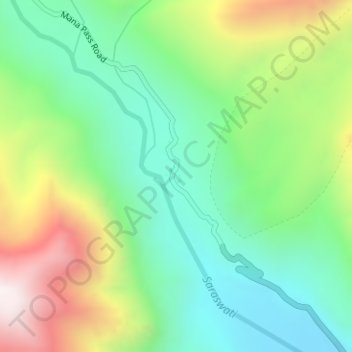
Name: Mana topographic map, elevation, terrain.

Location: Mana, Joshimath Tehsil, Chamoli District, Uttarakhand, India (30.96600 79.40952 30.96818 79.41237)

Average elevation: 16,270 ft

Minimum elevation: 15,171 ft

Maximum elevation: 18,291 ft

Other topographic maps

Click on a map to view its topography, its elevation and its terrain.

Saraswati

India > Uttarakhand > Joshimath Tehsil > Mana

Average elevation: 17,694 ft

Gamshali

India > Uttarakhand > Joshimath Tehsil

Average elevation: 12,546 ft

Modera

India > Uttarakhand > Joshimath Tehsil

Average elevation: 9,452 ft

Badrinath

India > Uttarakhand > Joshimath Tehsil

Average elevation: 13,294 ft

Gear up for your next adventure:

👟Trail Running Shoes - Lightweight shoes for trail runners
🕶️Glacier Sunglasses - Side shields to protect eyes from high-altitude snow glare
💧Water Purification System - Clean water on the trail with reliable purifiers
🗃️Trail First Aid Kit - Essential kit for outdoor injuries and emergencies
🥇GPS Hiking Watch - Multi‑sport GPS watch with navigation and trail tracking

As an Amazon Associate, this site earns from qualifying purchases at no extra cost to you.