Geolocate

Four by Four topographic map

Click on the map to display elevation.

About this map

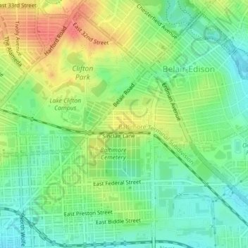
Name: Four by Four topographic map, elevation, terrain.

Location: Four by Four, Baltimore, Maryland, United States (39.31422 -76.58215 39.31681 -76.57299)

Average elevation: 135 ft

Minimum elevation: 52 ft

Maximum elevation: 249 ft

Maryland trails, hiking, mountain biking, running and outdoor activities

Other topographic maps

Click on a map to view its topography, its elevation and its terrain.

Ravens' Walk

United States > Maryland > Baltimore

Average elevation: 49 ft

Riverside Park

United States > Maryland > Baltimore

Average elevation: 16 ft

Gear up for your next adventure:

🗺️NatGeo Topo Maps - High-quality waterproof printed topographic maps of US Parks
🌧️Backpack Rain Cover - Keep gear dry in wet weather
🧢Sun Protection Hats - Wide-brimmed and UPF-rated hats for high-altitude sun safety
🩹Survival Bandages - High‑quality bandages for emergencies
🚁Photography Drones - Capture stunning aerial views of landforms and topography

As an Amazon Associate, this site earns from qualifying purchases at no extra cost to you.