
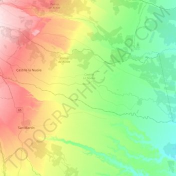
Guamal topographic map
Interactive map
Click on the map to display elevation.
About this map
Name: Guamal topographic map, elevation, terrain.
Location: Guamal, Meta, Colombia (3.70952 -73.76368 3.86257 -73.35698)
Average elevation: 1,122 ft
Minimum elevation: 761 ft
Maximum elevation: 1,752 ft
Other topographic maps
Click on a map to view its topography, its elevation and its terrain.
Vanguardia
Colombia > Meta > Villavicencio
Vanguardia, Villavicencio, Meta, 500010, Colombia
Average elevation: 1,493 ft
Villavicencio
Villavicencio, Capital, Meta, RAP (Especial) Central, Colombia
Average elevation: 1,545 ft
Salinas de Upin
Colombia > Meta > Restrepo > Restrepo
Salinas de Upin, Restrepo, Piedemonte, Meta, Colombia
Average elevation: 2,365 ft
El Castillo
Colombia > Meta > El Castillo
El Castillo, Ariari, Meta, Colombia
Average elevation: 2,936 ft
Villavicencio
Colombia > Meta > Villavicencio
Villavicencio, Capital, Meta, Orinoquia, Colombia
Average elevation: 2,854 ft
Samarcanda
Colombia > Meta > San Luis de Cubarral
Samarcanda, San Luis de Cubarral, Meta, Colombia
Average elevation: 1,772 ft