
Pilar topographic map
Click on the map to display elevation.
About this map
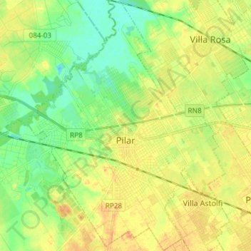
Name: Pilar topographic map, elevation, terrain.
Location: Pilar, Partido del Pilar, Buenos Aires, Argentina (-34.50135 -58.96152 -34.40074 -58.86571)
Average elevation: 62 ft
Minimum elevation: 0 ft
Maximum elevation: 128 ft
Other topographic maps
Click on a map to view its topography, its elevation and its terrain.
José León Suárez
Argentina > Buenos Aires > José León Suárez > José León Suárez
Average elevation: 56 ft
Ingeniero Maschwitz
Argentina > Buenos Aires > Ingeniero Maschwitz > Ingeniero Maschwitz
Average elevation: 33 ft