
Bozeman topographic map
Interactive map
Click on the map to display elevation.
About this map
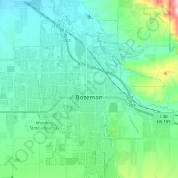
Name: Bozeman topographic map, elevation, terrain.
Location: Bozeman, Gallatin County, Montana, United States (45.63479 -111.11982 45.73326 -110.98424)
Average elevation: 4,905 ft
Minimum elevation: 4,567 ft
Maximum elevation: 6,476 ft
Bozeman is located at an elevation of 4,820 feet (1,470 m). The Bridger Mountains are to the north-northeast, the Tobacco Root Mountains to the west-southwest, the Big Belt Mountains and Horseshoe Hills to the northwest, the Hyalite Peaks of the northern Gallatin Range to the south and the Spanish Peaks of the northern Madison Range to the south-southwest. Bozeman is east of the continental divide, and Interstate 90 passes through the city. It is 84 miles (135 km) east of Butte, 125 miles (201 km) west of Billings, and 93 miles (150 km) north of Yellowstone National Park.
Other topographic maps
Click on a map to view its topography, its elevation and its terrain.
Big Sky
United States > Montana > Gallatin County
Big Sky, Gallatin County, Montana, United States
Average elevation: 7,989 ft
West Yellowstone
United States > Montana > Gallatin County
West Yellowstone, Gallatin County, Montana, United States
Average elevation: 6,673 ft
Logan
United States > Montana > Gallatin County
Logan, Gallatin County, Montana, United States
Average elevation: 4,245 ft
Clarkston
United States > Montana > Gallatin County
Clarkston, Gallatin County, Montana, United States
Average elevation: 4,055 ft
Gallatin River
United States > Montana > Gallatin County
Gallatin River, Gallatin Gateway, Gallatin County, Montana, United States
Average elevation: 4,951 ft
Manhattan
United States > Montana > Gallatin County
Manhattan, Gallatin County, Montana, United States
Average elevation: 4,245 ft
Three Forks
United States > Montana > Gallatin County
Three Forks, Gallatin County, Montana, United States
Average elevation: 4,098 ft
Four Corners
United States > Montana > Gallatin County
Four Corners, Gallatin County, Montana, United States
Average elevation: 4,820 ft
Gallatin National Forest
United States > Montana > Gallatin County
Gallatin National Forest, Gallatin County, Montana, United States
Average elevation: 6,772 ft
Bozeman
United States > Montana > Gallatin County > Bozeman
Bozeman, Gallatin County, Montana, 59715, United States
Average elevation: 5,509 ft
Big Sky Canyon Village
United States > Montana > Gallatin County > Big Sky Canyon Village
Big Sky Canyon Village, Gallatin County, Montana, United States
Average elevation: 6,542 ft
Belgrade
United States > Montana > Gallatin County
Belgrade, Gallatin County, Montana, 59714, United States
Average elevation: 4,446 ft