
Mount Knouff topographic map
Click on the map to display elevation.
About this map
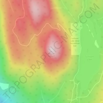
Name: Mount Knouff topographic map, elevation, terrain.
Average elevation: 4,019 ft
Minimum elevation: 3,209 ft
Maximum elevation: 4,724 ft
Other topographic maps
Click on a map to view its topography, its elevation and its terrain.
Little Heffley Lake
Canada > British Columbia > Thompson-Nicola Regional District > Area P (Rivers and the Peaks)
Average elevation: 3,396 ft
Niskonlith Lake
Canada > British Columbia > Thompson-Nicola Regional District > Area P (Rivers and the Peaks)
Average elevation: 1,972 ft
Knouff Lake
Canada > British Columbia > Thompson-Nicola Regional District > Area P (Rivers and the Peaks)
Average elevation: 4,098 ft
Badger Lake
Canada > British Columbia > Thompson-Nicola Regional District > Area P (Rivers and the Peaks)
Average elevation: 3,796 ft