Geolocate
👉 Easily get elevation data in JSON, GeoTIFF and KML formats using Elevation API
Thank you for supporting this site ❤️
Make a donation

Meitar topographic map

Click on the map to display elevation.

About this map

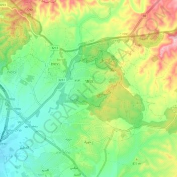
Name: Meitar topographic map, elevation, terrain.

Location: Meitar, Beersheba Subdistrict, South District, Israel (31.29928 34.88611 31.34806 34.98887)

Average elevation: 1,407 ft

Minimum elevation: 1,089 ft

Maximum elevation: 1,965 ft

Other topographic maps

Click on a map to view its topography, its elevation and its terrain.

Ein Bokek

Israel > South District > Tamar Regional Council

Average elevation: -912 ft

Dimona

Israel > South District

Dimona is located in the Negev Desert. The city stands at an elevation of around 550–600 metres (1,800–1,970 ft) above sea level.

Average elevation: 1,834 ft

Rahat

Israel > South District > Rahat

Average elevation: 738 ft

Kiryat Gat

Israel > South District

Average elevation: 433 ft

Ashdod

Israel > South District

Average elevation: 102 ft

Har Amasa

Israel > South District > Tamar Regional Council

Average elevation: 2,523 ft

Gear up for your next adventure:

🌡️Portable Weather Meter - Track weather conditions on the trail
🎒Gear Packing Cubes - Organize your backpack efficiently
🚑Emergency Bivvies - Heat-reflective sleeping bags for survival situations
🛡️Insect Repellent - Protection against bugs during outdoor activities
🗺️NatGeo Topo Maps - High-quality waterproof printed topographic maps of US Parks

As an Amazon Associate, this site earns from qualifying purchases at no extra cost to you.