
Lynxville topographic map
Interactive map
Click on the map to display elevation.
About this map
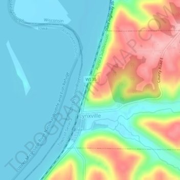
Name: Lynxville topographic map, elevation, terrain.
Location: Lynxville, Crawford County, Wisconsin, United States (43.24122 -91.06169 43.25916 -91.03140)
Average elevation: 755 ft
Minimum elevation: 610 ft
Maximum elevation: 1,106 ft
Other topographic maps
Click on a map to view its topography, its elevation and its terrain.
Wauzeka
United States > Wisconsin > Crawford County
Wauzeka, Crawford County, Wisconsin, United States
Average elevation: 748 ft
Bell Center
United States > Wisconsin > Crawford County
Bell Center, Crawford County, Wisconsin, 54631, United States
Average elevation: 876 ft
Town of Seneca
United States > Wisconsin > Crawford County
Town of Seneca, Crawford County, Wisconsin, United States
Average elevation: 981 ft
Mount Sterling
United States > Wisconsin > Crawford County
Mount Sterling, Crawford County, Wisconsin, 54645, United States
Average elevation: 1,102 ft
Ferryville
United States > Wisconsin > Crawford County
Ferryville, Crawford County, Wisconsin, United States
Average elevation: 722 ft
Soldiers Grove
United States > Wisconsin > Crawford County
Soldiers Grove, Crawford County, Wisconsin, United States
Average elevation: 883 ft
Steuben
United States > Wisconsin > Crawford County
Steuben, Crawford County, Wisconsin, United States
Average elevation: 833 ft
Town of Utica
United States > Wisconsin > Crawford County
Town of Utica, Crawford County, Wisconsin, United States
Average elevation: 1,010 ft
Barnum
United States > Wisconsin > Crawford County > Barnum
Barnum, Town of Haney, Crawford County, Wisconsin, United States
Average elevation: 866 ft
Eastman
United States > Wisconsin > Crawford County
Eastman, Crawford County, Wisconsin, United States
Average elevation: 1,119 ft
Prairie du Chien
United States > Wisconsin > Crawford County
Prairie du Chien, Crawford County, Wisconsin, United States
Average elevation: 745 ft