
Make a donation
Gear up for your next adventure:
As an Amazon Associate, this site earns from qualifying purchases at no extra cost to you.
San Leandro topographic map
Click on the map to display elevation.
Make a donation
Gear up for your next adventure:
As an Amazon Associate, this site earns from qualifying purchases at no extra cost to you.
San Leandro
The San Leandro Hills run above the city to the northeast. In the lower elevations of the city, an upper regionally contained aquifer is located 50 to 100 feet (15 to 30 m) below the surface. At least one deeper aquifer exists approximately 250 feet (75 m) below the surface. Some salt water intrusion has taken place in the San Leandro Cone. Shallow groundwater generally flows to the west, from the foothills toward San Francisco Bay. Shallow groundwater is contaminated in many of the locales of the lower elevation of the city. Contamination by gasoline, volatile organic compounds and some heavy metals has been recorded in a number of these lower-elevation areas.
Make a donation
Gear up for your next adventure:
As an Amazon Associate, this site earns from qualifying purchases at no extra cost to you.
About this map
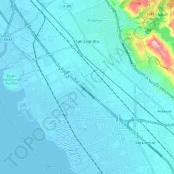
Name: San Leandro topographic map, elevation, terrain.
Location: San Leandro, Alameda County, California, United States (37.66741 -122.21007 37.74275 -122.12258)
Average elevation: 69 ft
Minimum elevation: -16 ft
Maximum elevation: 781 ft
Alameda County trails, hiking, mountain biking, running and outdoor activities
Make a donation
Gear up for your next adventure:
As an Amazon Associate, this site earns from qualifying purchases at no extra cost to you.
Other topographic maps
Click on a map to view its topography, its elevation and its terrain.
Coyote Hills Regional Park
United States > California > Alameda County > Fremont
Average elevation: 16 ft
Berkeley Hills
United States > California > Alameda County > Berkeley
The Berkeley Hills are bounded by the major Hayward Fault along their western base, and the minor Wildcat fault on their eastern side. The highest peaks are Grizzly Peak with an elevation of 1,754 feet (535 m) and Round Top, an extinct volcano with an elevation of 1,761 feet (537 m) and William Rust Summit at…
Average elevation: 518 ft
Make a donation
Gear up for your next adventure:
As an Amazon Associate, this site earns from qualifying purchases at no extra cost to you.
Make a donation
Gear up for your next adventure:
As an Amazon Associate, this site earns from qualifying purchases at no extra cost to you.
Contra Costa Rock Park
United States > California > Alameda County > Berkeley
Average elevation: 371 ft
Berkeley Hills
United States > California > Alameda County > Berkeley
The Berkeley Hills are bounded by the major Hayward Fault along their western base, and the minor Wildcat fault on their eastern side. The highest peaks are Grizzly Peak with an elevation of 1,754 feet (535 m) and Round Top, an extinct volcano with an elevation of 1,761 feet (537 m) and William Rust Summit at…
Average elevation: 518 ft
Drawbridge
United States > California > Alameda County > Fremont
Drawbridge (formerly Saline City) is a ghost town with an abandoned railroad station located at the southern end of the San Francisco Bay, next to Station Island, now a part of the city of Fremont, California, United States. It is located on the Union Pacific Railroad 6 miles (10 km) south of downtown Fremont,…
Average elevation: -3 ft
Make a donation
Gear up for your next adventure:
As an Amazon Associate, this site earns from qualifying purchases at no extra cost to you.