
Make a donation
Gear up for your next adventure:
As an Amazon Associate, this site earns from qualifying purchases at no extra cost to you.
Ak-Dovurak topographic map
Click on the map to display elevation.
Make a donation
Gear up for your next adventure:
As an Amazon Associate, this site earns from qualifying purchases at no extra cost to you.
About this map
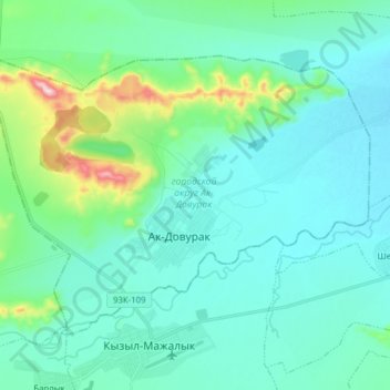
Name: Ak-Dovurak topographic map, elevation, terrain.
Location: Ak-Dovurak, Tuva Republic, Siberian Federal District, Russia (51.14814 90.51394 51.21812 90.66969)
Average elevation: 2,910 ft
Minimum elevation: 2,720 ft
Maximum elevation: 3,848 ft
Make a donation
Gear up for your next adventure:
As an Amazon Associate, this site earns from qualifying purchases at no extra cost to you.
Other topographic maps
Click on a map to view its topography, its elevation and its terrain.
Тоора-Хем
Russia > Tuva Republic > Todzhinsky Kozhuun
Due to high elevation, Toora-Khem has a subarctic climate (Köppen climate classification Dwc) with bitterly cold, long winters and mild, damp summers.
Average elevation: 3,025 ft
Make a donation
Gear up for your next adventure:
As an Amazon Associate, this site earns from qualifying purchases at no extra cost to you.