Geolocate

Cameron topographic map

Click on the map to display elevation.

About this map

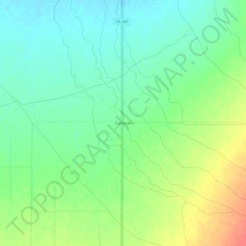
Name: Cameron topographic map, elevation, terrain.

Location: Cameron, Madison County, Montana, United States (45.18326 -111.69858 45.22326 -111.65858)

Average elevation: 5,387 ft

Minimum elevation: 5,322 ft

Maximum elevation: 5,499 ft

Madison County trails, hiking, mountain biking, running and outdoor activities

Other topographic maps

Click on a map to view its topography, its elevation and its terrain.

Ennis

United States > Montana > Madison County

Average elevation: 4,964 ft

Alder

United States > Montana > Madison County

Average elevation: 5,230 ft

Twin Bridges

United States > Montana > Madison County

Average elevation: 4,639 ft

Alder

United States > Montana > Madison County

Average elevation: 5,230 ft

Alder

United States > Montana > Madison County

Average elevation: 5,230 ft

Gear up for your next adventure:

🥄Camping Utensil Set - Lightweight utensils for outdoor meals
🎒Day Hiking Backpack - Lightweight backpack perfect for day trips and outdoor adventures
📶Vehicle Signal Boosters - Improve reception in rural areas while driving to trailheads
⛑️Personal Locator Beacon - Safety beacon for emergencies
🥩Freeze-Dried Meals - Nutritious and lightweight food for remote expeditions

As an Amazon Associate, this site earns from qualifying purchases at no extra cost to you.