
Make a donation
Gear up for your next adventure:
As an Amazon Associate, this site earns from qualifying purchases at no extra cost to you.
Olgiate Molgora topographic map
Click on the map to display elevation.
Make a donation
Gear up for your next adventure:
As an Amazon Associate, this site earns from qualifying purchases at no extra cost to you.
About this map
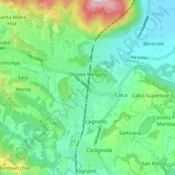
Name: Olgiate Molgora topographic map, elevation, terrain.
Location: Olgiate Molgora, Lecco, Lombardije, 23887, Italië (45.70385 9.38443 45.74957 9.42299)
Average elevation: 1,079 ft
Minimum elevation: 653 ft
Maximum elevation: 2,260 ft
Make a donation
Gear up for your next adventure:
As an Amazon Associate, this site earns from qualifying purchases at no extra cost to you.
Other topographic maps
Click on a map to view its topography, its elevation and its terrain.
Monte Barro
Italië > Lombardije > Lecco > Galbiate
De Monte Barro is een berg nabij Lecco in Lombardije, Italië, met een hoogte van 922 meter.
Average elevation: 1,348 ft