Geolocate

Union Township topographic map

Click on the map to display elevation.

About this map

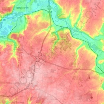
Name: Union Township topographic map, elevation, terrain.

Location: Union Township, Clermont County, Ohio, United States (39.04812 -84.31531 39.16669 -84.20826)

Average elevation: 768 ft

Minimum elevation: 479 ft

Maximum elevation: 938 ft

Clermont County trails, hiking, mountain biking, running and outdoor activities

Other topographic maps

Click on a map to view its topography, its elevation and its terrain.

Perintown

United States > Ohio > Clermont County

Average elevation: 653 ft

Cedron

United States > Ohio > Clermont County

Average elevation: 748 ft

The Highlands

United States > Ohio > Clermont County

Average elevation: 715 ft

Amelia

United States > Ohio > Clermont County

Average elevation: 869 ft

Sundale

United States > Ohio > Clermont County

Average elevation: 751 ft

Hills

United States > Ohio > Clermont County

Average elevation: 797 ft

Laurel

United States > Ohio > Clermont County

Average elevation: 827 ft

Saltair

United States > Ohio > Clermont County

Average elevation: 879 ft

The Highlands

United States > Ohio > Clermont County

Average elevation: 715 ft

The Highlands

United States > Ohio > Clermont County

Average elevation: 715 ft

Tobasco

United States > Ohio > Clermont County > Tobasco

Average elevation: 883 ft

Gear up for your next adventure:

🛏️Cold Weather Sleeping Bag - Warm sleeping bag for cold conditions
🎁Geography Themed Gifts - Unique gift ideas for map lovers and geography enthusiasts
🥾Hiking Shoes - Durable and comfortable shoes for trail hiking
🛡️Insect Repellent - Protection against bugs during outdoor activities
🧭Pro Hiking Compasses - High-accuracy liquid-filled compasses for topographic orientation

As an Amazon Associate, this site earns from qualifying purchases at no extra cost to you.