
Make a donation
Gear up for your next adventure:
As an Amazon Associate, this site earns from qualifying purchases at no extra cost to you.
Dellwood topographic map
Click on the map to display elevation.
Make a donation
Gear up for your next adventure:
As an Amazon Associate, this site earns from qualifying purchases at no extra cost to you.
About this map
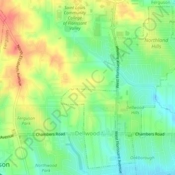
Name: Dellwood topographic map, elevation, terrain.
Location: Dellwood, Saint Louis County, Missouri, United States (38.74405 -90.29087 38.76908 -90.26214)
Average elevation: 554 ft
Minimum elevation: 472 ft
Maximum elevation: 653 ft
Saint Louis County trails, hiking, mountain biking, running and outdoor activities
Make a donation
Gear up for your next adventure:
As an Amazon Associate, this site earns from qualifying purchases at no extra cost to you.
Other topographic maps
Click on a map to view its topography, its elevation and its terrain.
Creve Coeur Lake
United States > Missouri > Saint Louis County > Maryland Heights
Average elevation: 492 ft
Make a donation
Gear up for your next adventure:
As an Amazon Associate, this site earns from qualifying purchases at no extra cost to you.
Jefferson Barracks
United States > Missouri > Saint Louis County > Jefferson Barracks
Average elevation: 459 ft
Simpson Park Lake
United States > Missouri > Saint Louis County > Valley Park
Average elevation: 453 ft
Make a donation
Gear up for your next adventure:
As an Amazon Associate, this site earns from qualifying purchases at no extra cost to you.
Make a donation
Gear up for your next adventure:
As an Amazon Associate, this site earns from qualifying purchases at no extra cost to you.
Sioux Passage Park
United States > Missouri > Saint Louis County > Old Jamestown > Possum Hollow
Average elevation: 492 ft
Greentree Park
United States > Missouri > Saint Louis County > Kirkwood > Osage Hills
Average elevation: 495 ft
Make a donation
Gear up for your next adventure:
As an Amazon Associate, this site earns from qualifying purchases at no extra cost to you.
Pattonville
United States > Missouri > Saint Louis County > Bridgeton > Pattonville
Average elevation: 571 ft