Geolocate

Pleasant Valley topographic map

Click on the map to display elevation.

About this map

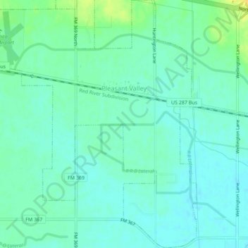
Name: Pleasant Valley topographic map, elevation, terrain.

Location: Pleasant Valley, Wichita County, Texas, United States (33.91723 -98.62070 33.95275 -98.58233)

Average elevation: 978 ft

Minimum elevation: 955 ft

Maximum elevation: 1,037 ft

Wichita County trails, hiking, mountain biking, running and outdoor activities

Other topographic maps

Click on a map to view its topography, its elevation and its terrain.

Haynesville

United States > Texas > Wichita County

Average elevation: 1,138 ft

Wichita Falls

United States > Texas > Wichita County

Average elevation: 988 ft

Bare Butte

United States > Texas > Wichita County

Average elevation: 997 ft

Gear up for your next adventure:

🩹Survival Bandages - High‑quality bandages for emergencies
🛶Inflatable Kayak - Portable kayak for rivers, lakes, and expeditions
🚗GPS Dash Cams - Record your scenic drives through mountain passes and canyons
🏔️Mountain Trail Maps - High‑detail maps for popular peaks
🥘Titanium Cookware - Durable, featherlight pots and pans for backpacking

As an Amazon Associate, this site earns from qualifying purchases at no extra cost to you.