Geolocate

Cheggino topographic map

Click on the map to display elevation.

About this map

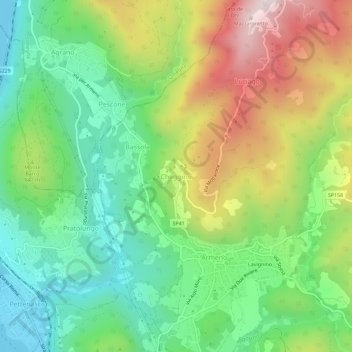
Name: Cheggino topographic map, elevation, terrain.

Location: Cheggino, Armeno, Novara, Piedmont, 28011, Italy (45.81165 8.41299 45.85165 8.45299)

Average elevation: 1,916 ft

Minimum elevation: 948 ft

Maximum elevation: 3,501 ft

Other topographic maps

Click on a map to view its topography, its elevation and its terrain.

Pella

Italy > Piedmont > Novara

Average elevation: 1,558 ft

Lake Orta

Italy > Piedmont > Novara > Pettenasco

Average elevation: 2,129 ft

Armeno

Italy > Piedmont > Novara

Average elevation: 2,047 ft

Casalbeltrame

Italy > Piedmont > Novara

Average elevation: 489 ft

Pombia

Italy > Piedmont > Novara

Average elevation: 817 ft

Gear up for your next adventure:

🧭GPS Watch Accessories - Bands and chargers for GPS watches
🧴Hand Sanitizer - Keep hands clean while hiking
🛡️Insect Repellent - Protection against bugs during outdoor activities
🧦Hiking Socks - Comfortable socks to prevent blisters on long hikes
🧯Emergency Survival Kit - All‑in‑one survival essentials for the backcountry

As an Amazon Associate, this site earns from qualifying purchases at no extra cost to you.