Geolocate

Pombia topographic map

Click on the map to display elevation.

About this map

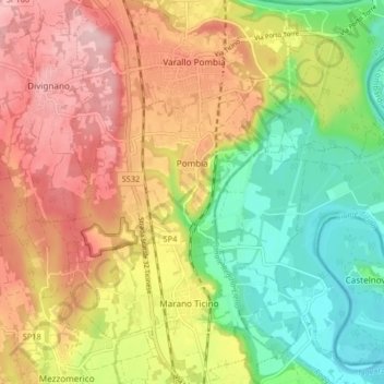
Name: Pombia topographic map, elevation, terrain.

Location: Pombia, Novara, Piedmont, 28050, Italy (45.63218 8.60684 45.66084 8.68861)

Average elevation: 817 ft

Minimum elevation: 512 ft

Maximum elevation: 1,138 ft

Other topographic maps

Click on a map to view its topography, its elevation and its terrain.

Canton della Lanca

Italy > Piedmont > Novara > Oleggio

Average elevation: 643 ft

Cheggino

Italy > Piedmont > Novara

Average elevation: 1,916 ft

Gear up for your next adventure:

🕶️Glacier Sunglasses - Side shields to protect eyes from high-altitude snow glare
🔦LED Headlamp - Bright and durable LED headlamp for night navigation
📷Action Camera - Capture your outdoor adventures in HD
GPS Sports Watch - GPS watch for running, hiking and training
🔦Compact Flashlight - Reliable flashlight for emergencies

As an Amazon Associate, this site earns from qualifying purchases at no extra cost to you.