Geolocate

Bear topographic map

Click on the map to display elevation.

About this map

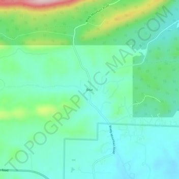
Name: Bear topographic map, elevation, terrain.

Location: Bear, Garland County, Arkansas, 71968, United States (34.51453 -93.29380 34.55453 -93.25380)

Average elevation: 709 ft

Minimum elevation: 505 ft

Maximum elevation: 1,329 ft

Garland County trails, hiking, mountain biking, running and outdoor activities

Other topographic maps

Click on a map to view its topography, its elevation and its terrain.

Mountain Pine

United States > Arkansas > Garland County

Average elevation: 522 ft

Rockwell

United States > Arkansas > Garland County > Rockwell

Average elevation: 453 ft

Piney

United States > Arkansas > Garland County > Hot Springs

Average elevation: 479 ft

Lonsdale

United States > Arkansas > Garland County

Average elevation: 489 ft

Gear up for your next adventure:

🥇GPS Hiking Watch - Multi‑sport GPS watch with navigation and trail tracking
📷Action Cameras - Rugged cameras to document your journeys across rugged terrain
🥾Women's Hiking Boots - Top-rated trail boots with ankle support and superior grip
🛡️Insect Repellent - Protection against bugs during outdoor activities
🪑Ultralight Camp Chairs - Portable seating for resting after a long day of mapping

As an Amazon Associate, this site earns from qualifying purchases at no extra cost to you.