
Asosa topographic map
Click on the map to display elevation.
Asosa
Asosa or Assosa is the capital of Benishangul-Gumuz Region, Ethiopia. Located in the Asosa Zone, this town has a latitude and longitude of 10°04′N 34°31′E / 10.067°N 34.517°E / 10.067; 34.517, with an elevation of 1,570 meters.
About this map
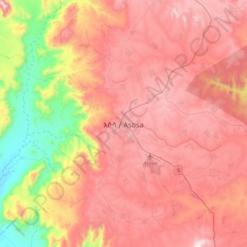
Name: Asosa topographic map, elevation, terrain.
Location: Asosa, Benishangul-Gumuz Region, Ethiopia (9.90464 34.38370 10.22464 34.70370)
Average elevation: 4,268 ft
Minimum elevation: 2,142 ft
Maximum elevation: 5,814 ft
Other topographic maps
Click on a map to view its topography, its elevation and its terrain.
Grand Ethiopian Renaissance Dam
Ethiopia > Benishangul-Gumuz Region
The first phase of filling the reservoir began in July 2020 and in August 2020 the water level rose to an altitude of 540 meters (40 meters higher than the bottom of the river, which is at an altitude of 500 meters above sea level). The second phase of filling was completed on 19 July 2021, with water levels…
Average elevation: 1,821 ft