
Snowshill topographic map
Click on the map to display elevation.
About this map
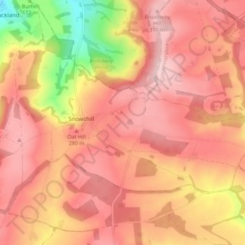
Name: Snowshill topographic map, elevation, terrain.
Average elevation: 817 ft
Minimum elevation: 299 ft
Maximum elevation: 1,063 ft
Other topographic maps
Click on a map to view its topography, its elevation and its terrain.
Bamfurlong
United Kingdom > England > Gloucestershire > Tewkesbury > Staverton
Average elevation: 112 ft
Alney Island
United Kingdom > England > Gloucestershire > Tewkesbury > Maisemore
Average elevation: 43 ft
Bishop's Cleeve
United Kingdom > England > Gloucestershire > Tewkesbury > Gotherington
Average elevation: 167 ft
Little Shurdington
United Kingdom > England > Gloucestershire > Tewkesbury > Bentham
Average elevation: 367 ft
Lower Apperley
United Kingdom > England > Gloucestershire > Tewkesbury > Apperley
Average elevation: 52 ft
Dumbleton
United Kingdom > England > Gloucestershire > Tewkesbury > Dumbleton
Average elevation: 217 ft
Wood Stanway
United Kingdom > England > Gloucestershire > Tewkesbury > Stanway
Average elevation: 561 ft