Geolocate

Churchdown Hill topographic map

Click on the map to display elevation.

About this map

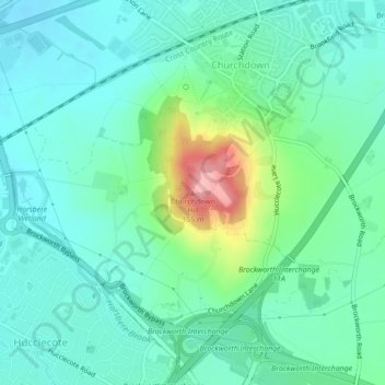
Name: Churchdown Hill topographic map, elevation, terrain.

Location: Churchdown Hill, Tewkesbury, Gloucestershire, England, GL3 2LQ, United Kingdom (51.86800 -2.17590 51.86810 -2.17580)

Average elevation: 161 ft

Minimum elevation: 56 ft

Maximum elevation: 495 ft

Other topographic maps

Click on a map to view its topography, its elevation and its terrain.

Twyning

United Kingdom > England > Gloucestershire > Tewkesbury

Average elevation: 72 ft

Brockworth

United Kingdom > England > Gloucestershire > Tewkesbury

Average elevation: 269 ft

Winchcombe

United Kingdom > England > Gloucestershire > Tewkesbury

Average elevation: 515 ft

Deerhurst

United Kingdom > England > Gloucestershire > Tewkesbury

Average elevation: 52 ft

Snowshill

United Kingdom > England > Gloucestershire > Tewkesbury

Average elevation: 817 ft

Hawling

United Kingdom > England > Gloucestershire > Tewkesbury

Average elevation: 791 ft

Woodmancote

United Kingdom > England > Gloucestershire > Tewkesbury

Average elevation: 430 ft

Badgeworth

United Kingdom > England > Gloucestershire > Tewkesbury

Average elevation: 272 ft

Twigworth

United Kingdom > England > Gloucestershire > Tewkesbury

Average elevation: 46 ft

Stanway

United Kingdom > England > Gloucestershire > Tewkesbury > Stanway

Average elevation: 558 ft

Norton

United Kingdom > England > Gloucestershire > Tewkesbury

Average elevation: 59 ft

Gretton

United Kingdom > England > Gloucestershire > Tewkesbury

Average elevation: 328 ft

Deerhurst

United Kingdom > England > Gloucestershire > Tewkesbury

Average elevation: 56 ft

Sandhurst

United Kingdom > England > Gloucestershire > Tewkesbury

Average elevation: 62 ft

Snowshill

United Kingdom > England > Gloucestershire > Tewkesbury

Average elevation: 817 ft

Northway

United Kingdom > England > Gloucestershire > Tewkesbury

Average elevation: 69 ft

Twyning

United Kingdom > England > Gloucestershire > Tewkesbury

Average elevation: 72 ft

Winchcombe

United Kingdom > England > Gloucestershire > Tewkesbury

Average elevation: 515 ft

Brockworth

United Kingdom > England > Gloucestershire > Tewkesbury

Average elevation: 269 ft

Hasfield

United Kingdom > England > Gloucestershire > Tewkesbury

Average elevation: 69 ft

Gear up for your next adventure:

🧢Sun Protection Hats - Wide-brimmed and UPF-rated hats for high-altitude sun safety
🌄Hiking Binoculars - Compact binoculars for scenic views and trail spotting
🎒Trail Energy Bars - High‑calorie bars for hiking energy
🗺️NatGeo Topo Maps - High-quality waterproof printed topographic maps of US Parks
🥾Hiking Shoes - Durable and comfortable shoes for trail hiking

As an Amazon Associate, this site earns from qualifying purchases at no extra cost to you.