Geolocate

Alghero topographic map

Click on the map to display elevation.

About this map

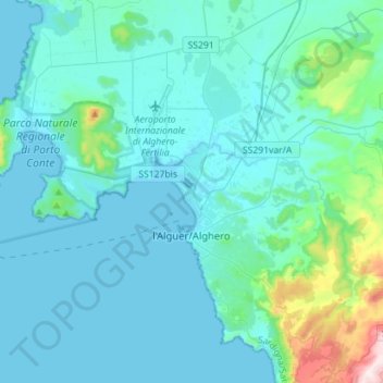
Name: Alghero topographic map, elevation, terrain.

Location: Alghero, Sassari, Sardinia, Italy (40.49496 8.13777 40.67399 8.42032)

Average elevation: 243 ft

Minimum elevation: -3 ft

Maximum elevation: 2,310 ft

Other topographic maps

Click on a map to view its topography, its elevation and its terrain.

Pittulongu

Italy > Sardinia > Sassari > Olbia

Average elevation: 72 ft

Lu Bagnu

Italy > Sardinia > Sassari

Average elevation: 184 ft

Li Scalitti

Italy > Sardinia > Sassari > Badesi

Average elevation: 233 ft

Gear up for your next adventure:

💧Water Purification System - Clean water on the trail with reliable purifiers
🌎3D Topographic Globes - Raised relief globes for a tactile understanding of geography
🧭Hiking Compass - Precision compass for reliable navigation in the wilderness
🧭Compass with Lanyard - Easy‑carry compass for navigation
🔥Camping Stove - Portable stove for camping and backcountry cooking

As an Amazon Associate, this site earns from qualifying purchases at no extra cost to you.