
Bwindi Impenetrable National Park topographic map
Interactive map
Click on the map to display elevation.
Bwindi Impenetrable National Park
Species diversity is a feature of the park. It provides habitat for 120 species of mammals, 348 species of birds, 220 species of butterflies, 27 species of frogs, chameleons, geckos, and many endangered species. Floristically, the park is among the most diverse forests in East Africa, with more than 1,000 flowering plant species, including 163 species of trees and 104 species of ferns. The northern (low elevation) sector has many species of Guineo-Congolian flora, including two endangered species, the brown mahogany and Brazzeia longipedicellata. In particular, the area shares in the high levels of endemisms of the Albertine Rift.
About this map
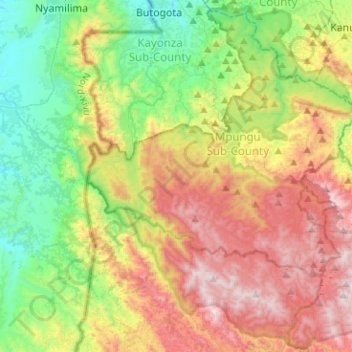
Name: Bwindi Impenetrable National Park topographic map, elevation, terrain.
Average elevation: 5,390 ft
Minimum elevation: 3,589 ft
Maximum elevation: 8,025 ft
Other topographic maps
Click on a map to view its topography, its elevation and its terrain.
Kisoro
Kisoro is approximately 76 kilometres (47 mi), by road, west of Kabale, the largest city in the Kigezi sub-region. This is approximately 484 kilometres (301 mi), by road, southwest of Kampala, the capital of Uganda and the country's largest city. Kisoro is east of Rumangabo and the Virunga Mountains in the…
Average elevation: 6,270 ft