Geolocate

Bobon topographic map

Click on the map to display elevation.

About this map

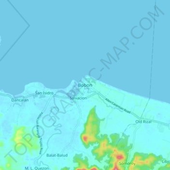
Name: Bobon topographic map, elevation, terrain.

Location: Bobon, Northern Samar, Eastern Visayas, 6401, Philippines (12.48578 124.52420 12.56578 124.60420)

Average elevation: 20 ft

Minimum elevation: -10 ft

Maximum elevation: 318 ft

Other topographic maps

Click on a map to view its topography, its elevation and its terrain.

Biri

Philippines > Northern Samar

Average elevation: 3 ft

Tarnate

Philippines > Northern Samar > San Vicente

Average elevation: 89 ft

Cagnipa Island

Philippines > Northern Samar > Biri > Santo Niño

Average elevation: 16 ft

Sitio Rabbit

Philippines > Northern Samar > Victoria

Average elevation: 89 ft

Capul

Philippines > Northern Samar

Average elevation: 16 ft

Capul Island

Philippines > Northern Samar > Capul

Average elevation: 46 ft

Palanit

Philippines > Northern Samar

Average elevation: 171 ft

Cagnipa Island

Philippines > Northern Samar > Biri > Santo Niño

Average elevation: 16 ft

Catubig River

Philippines > Northern Samar

Average elevation: 125 ft

Catarman

Philippines > Northern Samar

Average elevation: 164 ft

Catarman

Philippines > Northern Samar

Average elevation: 167 ft

Catarman

Philippines > Northern Samar

Average elevation: 167 ft

Gear up for your next adventure:

🌡️Handheld Weather Meters - Measure wind, temp, and pressure for safe mountain travel
🔪Outdoor Multitools - Essential survival tools for gear repair and field use
🧷Carabiner Set - Durable clips for gear attachment
🧥Men's Rain Shells - Premium waterproof and breathable jackets for mountain weather
🛶Inflatable Kayak - Portable kayak for rivers, lakes, and expeditions

As an Amazon Associate, this site earns from qualifying purchases at no extra cost to you.