
Stewartstown topographic map
Click on the map to display elevation.
About this map
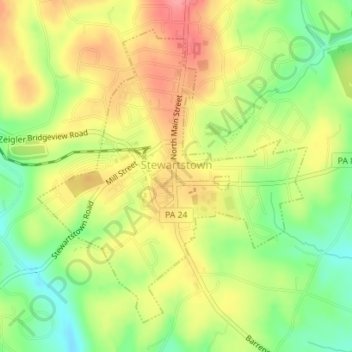
Name: Stewartstown topographic map, elevation, terrain.
Location: Stewartstown, York County, Pennsylvania, United States (39.74158 -76.60521 39.76407 -76.57833)
Average elevation: 823 ft
Minimum elevation: 676 ft
Maximum elevation: 961 ft
York County trails, hiking, mountain biking, running and outdoor activities
Other topographic maps
Click on a map to view its topography, its elevation and its terrain.
Fairview Park
United States > Pennsylvania > York County > Fairview Township > Fairview Park
Average elevation: 614 ft
Pinchot Lake
United States > Pennsylvania > York County > Warrington Township > Rossville > Alpine
Average elevation: 502 ft
Freysville
United States > Pennsylvania > York County > Windsor Township > Freysville
Average elevation: 764 ft
Spring Plains
United States > Pennsylvania > York County > Springettsbury Township
Average elevation: 495 ft
Airville
United States > Pennsylvania > York County > Lower Chanceford Township
Average elevation: 686 ft
Campbell Estates
United States > Pennsylvania > York County > West Manchester Township
Average elevation: 449 ft