
London topographic map
Click on the map to display elevation.
London
London is located in central Laurel County at 37°7′39″N 84°5′3″W / 37.12750°N 84.08417°W / 37.12750; -84.08417 (37.127504, -84.084181) and at an elevation of 1,240 feet (380 m).
About this map
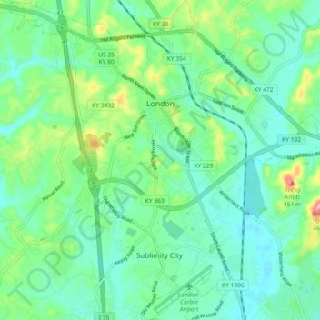
Name: London topographic map, elevation, terrain.
Location: London, Laurel County, Kentucky, 40741, United States (37.07976 -84.12626 37.15226 -84.03596)
Average elevation: 1,214 ft
Minimum elevation: 1,109 ft
Maximum elevation: 1,516 ft
Laurel County trails, hiking, mountain biking, running and outdoor activities
Other topographic maps
Click on a map to view its topography, its elevation and its terrain.