
Make a donation
Gear up for your next adventure:
As an Amazon Associate, this site earns from qualifying purchases at no extra cost to you.
Mamusa Local Municipality topographic map
Click on the map to display elevation.
Make a donation
Gear up for your next adventure:
As an Amazon Associate, this site earns from qualifying purchases at no extra cost to you.
About this map
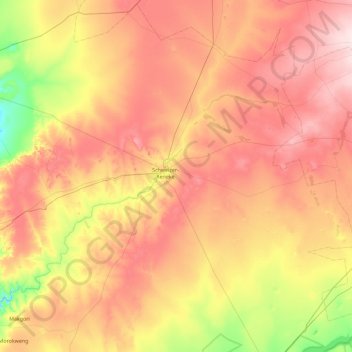
Name: Mamusa Local Municipality topographic map, elevation, terrain.
Average elevation: 4,360 ft
Minimum elevation: 3,898 ft
Maximum elevation: 4,803 ft
Make a donation
Gear up for your next adventure:
As an Amazon Associate, this site earns from qualifying purchases at no extra cost to you.
Other topographic maps
Click on a map to view its topography, its elevation and its terrain.
Schweizer-Reneke
South Africa > North West > Dr Ruth Segomotsi Mompati District Municipality > Mamusa Local Municipality
Average elevation: 4,324 ft
Vryburg
South Africa > North West > Dr Ruth Segomotsi Mompati District Municipality > Naledi Local Municipality
Average elevation: 3,953 ft
Reivilo
South Africa > North West > Dr Ruth Segomotsi Mompati District Municipality > Greater Taung Local Municipality
Average elevation: 4,685 ft
Mokgareng
South Africa > North West > Dr Ruth Segomotsi Mompati District Municipality > Greater Taung Local Municipality
Average elevation: 3,576 ft
Make a donation
Gear up for your next adventure:
As an Amazon Associate, this site earns from qualifying purchases at no extra cost to you.
Christiana
South Africa > North West > Dr Ruth Segomotsi Mompati District Municipality > Lekwa-Teemane Local Municipality
Average elevation: 3,973 ft
Ganyesa
South Africa > North West > Dr Ruth Segomotsi Mompati District Municipality > Kagisano-Molopo Local Municipality
Average elevation: 4,236 ft
Matolong
South Africa > North West > Dr Ruth Segomotsi Mompati District Municipality > Greater Taung Local Municipality
Average elevation: 3,629 ft
Molelema
South Africa > North West > Dr Ruth Segomotsi Mompati District Municipality > Greater Taung Local Municipality
Average elevation: 4,252 ft
Make a donation
Gear up for your next adventure:
As an Amazon Associate, this site earns from qualifying purchases at no extra cost to you.
Taung
South Africa > North West > Dr Ruth Segomotsi Mompati District Municipality > Greater Taung Local Municipality
Average elevation: 3,619 ft
Vryburg
South Africa > North West > Dr Ruth Segomotsi Mompati District Municipality > Naledi Local Municipality
Average elevation: 3,953 ft
Vryburg
South Africa > North West > Dr Ruth Segomotsi Mompati District Municipality > Naledi Local Municipality
Average elevation: 3,953 ft
Ganyesa
South Africa > North West > Dr Ruth Segomotsi Mompati District Municipality > Kagisano-Molopo Local Municipality
Average elevation: 4,236 ft
Make a donation
Gear up for your next adventure:
As an Amazon Associate, this site earns from qualifying purchases at no extra cost to you.
Schweizer-Reneke
South Africa > North West > Dr Ruth Segomotsi Mompati District Municipality > Mamusa Local Municipality
Average elevation: 4,324 ft
Bloemhof
South Africa > North West > Dr Ruth Segomotsi Mompati District Municipality > Lekwa-Teemane Local Municipality
Average elevation: 4,049 ft
Manokwane
South Africa > North West > Dr Ruth Segomotsi Mompati District Municipality > Greater Taung Local Municipality
Average elevation: 3,757 ft
Vryburg
South Africa > North West > Dr Ruth Segomotsi Mompati District Municipality > Naledi Local Municipality
Average elevation: 3,953 ft
Make a donation
Gear up for your next adventure:
As an Amazon Associate, this site earns from qualifying purchases at no extra cost to you.