
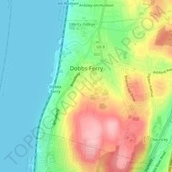
Village of Dobbs Ferry topographic map
Interactive map
Click on the map to display elevation.
About this map
Name: Village of Dobbs Ferry topographic map, elevation, terrain.
Average elevation: 177 ft
Minimum elevation: 0 ft
Maximum elevation: 466 ft
Westchester County trails, hiking, mountain biking, running and outdoor activities
Other topographic maps
Click on a map to view its topography, its elevation and its terrain.
Buckhout Corners
United States > New York > Westchester County > Village of Briarcliff Manor
Average elevation: 367 ft
Mohegan Heights
United States > New York > Westchester County > City of Yonkers
Average elevation: 190 ft
Lake Katonah
United States > New York > Westchester County > Town of Lewisboro
Average elevation: 417 ft
South Ridge
United States > New York > Westchester County > Village of Rye Brook
Average elevation: 121 ft
Murdock Woods
United States > New York > Westchester County > Town of Mamaroneck
Average elevation: 151 ft
Turkey Mountain
United States > New York > Westchester County > Town of Yorktown
Average elevation: 466 ft
Sleepy Hollow Manor
United States > New York > Westchester County > Village of Sleepy Hollow
Average elevation: 135 ft
Furnace Woods
United States > New York > Westchester County > Town of Cortlandt
Average elevation: 381 ft
Salem Center
United States > New York > Westchester County > Town of North Salem
Average elevation: 482 ft
Isle of San Souci
United States > New York > Westchester County > City of New Rochelle
Average elevation: 23 ft
Van Cortlandtville
United States > New York > Westchester County > Town of Cortlandt
Average elevation: 262 ft
South Salem
United States > New York > Westchester County > Town of Lewisboro
Average elevation: 571 ft
Getty Square
United States > New York > Westchester County > City of Yonkers > Ludlow
Average elevation: 102 ft
Wykagyl Park
United States > New York > Westchester County > City of New Rochelle
Average elevation: 135 ft
Murray Hill
United States > New York > Westchester County > Village of Scarsdale
Average elevation: 259 ft
Sun Haven
United States > New York > Westchester County > City of New Rochelle
Average elevation: 66 ft
West Mount Vernon
United States > New York > Westchester County > City of Mount Vernon
Average elevation: 161 ft
Park Hill
United States > New York > Westchester County > City of Yonkers > Park Hill
Average elevation: 141 ft
Vista
United States > New York > Westchester County > Town of Lewisboro > Vista
Average elevation: 505 ft
Bedford Hills
United States > New York > Westchester County > Town of Bedford > Bedford Hills
Average elevation: 374 ft
Purdys Grove
United States > New York > Westchester County > Village of Port Chester
Average elevation: 46 ft