
Make a donation
Gear up for your next adventure:
As an Amazon Associate, this site earns from qualifying purchases at no extra cost to you.
Stangerode topographic map
Click on the map to display elevation.
Make a donation
Gear up for your next adventure:
As an Amazon Associate, this site earns from qualifying purchases at no extra cost to you.
About this map
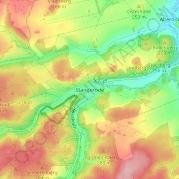
Name: Stangerode topographic map, elevation, terrain.
Average elevation: 814 ft
Minimum elevation: 577 ft
Maximum elevation: 1,050 ft
Make a donation
Gear up for your next adventure:
As an Amazon Associate, this site earns from qualifying purchases at no extra cost to you.
Other topographic maps
Click on a map to view its topography, its elevation and its terrain.
Alterode
Deutschland > Sachsen-Anhalt > Mansfeld-Südharz > Arnstein
Das jährliche Heimat- und Schützenfest, das vier Tage gefeiert wird, steht ganz unter der Schirmherrschaft der Alteröder Schützengesellschaft 1867 e. V. Höhepunkt des Schützenfestes ist das Ausschießen des Schützenkönigs sowohl unter den Erwachsenen und als auch unter den Kindern.
Average elevation: 725 ft
Sylda
Deutschland > Sachsen-Anhalt > Mansfeld-Südharz > Arnstein > Sylda
„Was aus dem alten Siegel eindeutig erkennbar ist, sind die Symbole der Ringe und der Krone. Kronen unterliegen in der Heraldik einer strengen und genauen Hierarchie, d. h. je nach Adelsstand war auch die Krone in einer bestimmten Weise gezeichnet. Vermutungen, es könne sich die Krone auf einen höheren…
Average elevation: 758 ft
Make a donation
Gear up for your next adventure:
As an Amazon Associate, this site earns from qualifying purchases at no extra cost to you.