
Noun topographic map
Interactive map
Click on the map to display elevation.
About this map
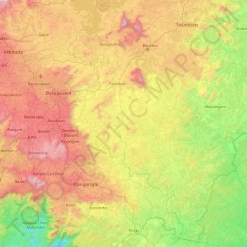
Name: Noun topographic map, elevation, terrain.
Location: Noun, Ndé, OU, Cameroun (4.90781 10.45625 5.81807 11.10151)
Average elevation: 3,422 ft
Minimum elevation: 873 ft
Maximum elevation: 7,270 ft
Other topographic maps
Click on a map to view its topography, its elevation and its terrain.
Bafou Centre
Cameroun > OU > Bafou Centre
Bafou Centre, Menoua, OU, Cameroun
Average elevation: 4,977 ft
Chutes d'Ekom Nkam
Chutes d'Ekom Nkam, Banwa, Haut-Nkam, OU, Cameroun
Average elevation: 2,051 ft