Geolocate

Halstenbek topographic map

Click on the map to display elevation.

About this map

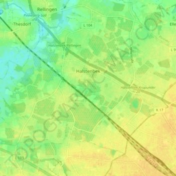
Name: Halstenbek topographic map, elevation, terrain.

Location: Halstenbek, Kreis Pinneberg, Schleswig-Holstein, 25469, Germany (53.60930 9.79880 53.64728 9.88499)

Average elevation: 52 ft

Minimum elevation: 7 ft

Maximum elevation: 82 ft

Other topographic maps

Click on a map to view its topography, its elevation and its terrain.

Dune

Germany > Schleswig-Holstein > Kreis Pinneberg > Helgoland

Average elevation: 0 ft

Pinneberg

Germany > Schleswig-Holstein > Kreis Pinneberg

Average elevation: 36 ft

Knust

Germany > Schleswig-Holstein > Kreis Pinneberg > Quickborn

Average elevation: 46 ft

Gear up for your next adventure:

📦Dry Bags Set - Waterproof storage for electronics and clothes
🎒Day Hiking Backpack - Lightweight backpack perfect for day trips and outdoor adventures
🧤Hiking Gloves - Protective gloves for rugged trails
🏥Hiking First Aid Kits - Comprehensive medical kits for remote trail injuries
📦Gear Storage Bags - Organize and protect outdoor equipment

As an Amazon Associate, this site earns from qualifying purchases at no extra cost to you.