Geolocate

River Derwent topographic map

Click on the map to display elevation.

River Derwent

Rainfall and climate conditions vary slightly across the Derwent catchment area due to the topography. Annual rainfall ranges from averages of 600 millimetres (24 in) at Barmby Barrage to over 1,100 millimetres (43 in) at its source on the North York Moors.

Wikipedia (CC-BY-SA 3.0)

About this map

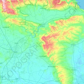
Name: River Derwent topographic map, elevation, terrain.

Location: River Derwent, North Yorkshire, York and North Yorkshire, England, United Kingdom (53.74899 -0.96947 54.29850 -0.47018)

Average elevation: 184 ft

Minimum elevation: -3 ft

Maximum elevation: 1,109 ft

Other topographic maps

Click on a map to view its topography, its elevation and its terrain.

Stearsby

United Kingdom > England > North Yorkshire

Average elevation: 299 ft

Wiganthorpe

United Kingdom > England > North Yorkshire

Average elevation: 269 ft

Thornborough

United Kingdom > England > North Yorkshire

Average elevation: 141 ft

Ganthorpe

United Kingdom > England > North Yorkshire

Average elevation: 240 ft

Robin Hill Rigg

United Kingdom > England > North Yorkshire > Malham

Average elevation: 1,302 ft

Wensleydale

United Kingdom > England > North Yorkshire > Aysgarth

Average elevation: 1,217 ft

South Stainley

United Kingdom > England > North Yorkshire

Average elevation: 256 ft

West Burton

United Kingdom > England > North Yorkshire

Average elevation: 915 ft

Catterick

United Kingdom > England > North Yorkshire

Average elevation: 200 ft

Foxup

United Kingdom > England > North Yorkshire

Average elevation: 1,529 ft

Burtersett

United Kingdom > England > North Yorkshire > Hawes

Average elevation: 1,099 ft

Sneaton Thorpe

United Kingdom > England > North Yorkshire

Average elevation: 476 ft

Pen-y-ghent

United Kingdom > England > North Yorkshire

Average elevation: 1,598 ft

Staxton Wold

United Kingdom > England > North Yorkshire > Willerby

Average elevation: 489 ft

Raw

United Kingdom > England > North Yorkshire > Fylingthorpe

Average elevation: 397 ft

Easby Moor

United Kingdom > England > North Yorkshire > Easby > Little Ayton

Average elevation: 604 ft

Gayle

United Kingdom > England > North Yorkshire > Hawes

Average elevation: 1,086 ft

Dovestone

United Kingdom > England > North Yorkshire

Average elevation: 971 ft

Keld

United Kingdom > England > North Yorkshire

Average elevation: 1,407 ft

Bouthwaite

United Kingdom > England > North Yorkshire

Average elevation: 745 ft

Skipton Moor

United Kingdom > England > North Yorkshire > Skipton

Average elevation: 755 ft

Nidd Head

United Kingdom > England > North Yorkshire

Average elevation: 1,831 ft

Great Whernside

United Kingdom > England > North Yorkshire

Average elevation: 1,903 ft

Cray

United Kingdom > England > North Yorkshire > Buckden

Average elevation: 1,463 ft

Port Mulgrave

United Kingdom > England > North Yorkshire > Staithes

Average elevation: 141 ft

Low Ellington

United Kingdom > England > North Yorkshire

Average elevation: 397 ft

Leeming Bar

United Kingdom > England > North Yorkshire

Average elevation: 125 ft

Hetton

United Kingdom > England > North Yorkshire

Average elevation: 692 ft

Black Hambleton

United Kingdom > England > North Yorkshire > Hawnby

Average elevation: 961 ft

Waldendale

United Kingdom > England > North Yorkshire > West Burton

Average elevation: 1,312 ft

Fremington Edge

United Kingdom > England > North Yorkshire

Average elevation: 1,204 ft

Low Row

United Kingdom > England > North Yorkshire

Average elevation: 1,175 ft

Thwaite

United Kingdom > England > North Yorkshire

Average elevation: 1,368 ft

Gaping Gill

United Kingdom > England > North Yorkshire

Average elevation: 1,437 ft

Ryther

United Kingdom > England > North Yorkshire > Selby

Average elevation: 26 ft

Staintondale

United Kingdom > England > North Yorkshire

Average elevation: 446 ft

Barlby

United Kingdom > England > North Yorkshire

Average elevation: 16 ft

Ramsgill

United Kingdom > England > North Yorkshire

Average elevation: 853 ft

Barlby

United Kingdom > England > North Yorkshire

Average elevation: 16 ft

Ingleborough

United Kingdom > England > North Yorkshire > Ingleton

Average elevation: 1,637 ft

Staithes

United Kingdom > England > North Yorkshire

Average elevation: 92 ft

Tan Hill

United Kingdom > England > North Yorkshire

Average elevation: 1,627 ft

Kingsdale

United Kingdom > England > North Yorkshire > Ingleton

Average elevation: 1,234 ft

Long Ashes Park

United Kingdom > England > North Yorkshire

Average elevation: 856 ft

Staithes

United Kingdom > England > North Yorkshire

Average elevation: 92 ft

Leeming

United Kingdom > England > North Yorkshire

Average elevation: 118 ft

Ravenscar

United Kingdom > England > North Yorkshire

Average elevation: 384 ft

Harrogate

United Kingdom > England > North Yorkshire

Harrogate is situated on the edge of the Yorkshire Dales, with the Vale of York to the east and the upland Yorkshire Dales to the west and north-west. It has a dry and mild climate, typical of places in the rain shadow of the Pennines. It is on the A59 from Skipton to York. At an altitude of between 100 and…

Average elevation: 348 ft

Nidderdale

United Kingdom > England > North Yorkshire

Average elevation: 522 ft

Urra Moor

United Kingdom > England > North Yorkshire

Average elevation: 1,053 ft

Earl Crag

United Kingdom > England > North Yorkshire > Cowling

Average elevation: 843 ft

Caldbergh

United Kingdom > England > North Yorkshire > Coverham

Average elevation: 915 ft

Braythorn

United Kingdom > England > North Yorkshire > Harrogate

Average elevation: 512 ft

Pen Hill

United Kingdom > England > North Yorkshire > Cowesby

Average elevation: 564 ft

Thornthwaite

United Kingdom > England > North Yorkshire

Average elevation: 705 ft

Lindley Moor

United Kingdom > England > North Yorkshire > Lindley

Average elevation: 738 ft

Hardraw

United Kingdom > England > North Yorkshire > Appersett

Average elevation: 1,066 ft

Horsehouse

United Kingdom > England > North Yorkshire

Horsehouse is a village in Coverdale in the Yorkshire Dales, North Yorkshire, England. It is listed as a hamlet in many texts, but the presence of the church makes it a village. The River Cover runs near the village, and it lies some 6 miles (9.7 km) and 8.5 miles (13.7 km) south-west of Middleham and Leyburn…

Average elevation: 1,161 ft

Ripley Castle

United Kingdom > England > North Yorkshire > Ripley

Average elevation: 262 ft

Osgodby

United Kingdom > England > North Yorkshire > Barlby

Average elevation: 20 ft

Ilton

United Kingdom > England > North Yorkshire

Average elevation: 722 ft

West Heslerton

United Kingdom > England > North Yorkshire

Average elevation: 276 ft

Muscoates

United Kingdom > England > North Yorkshire > Nunnington

Average elevation: 115 ft

Danby Beacon

United Kingdom > England > North Yorkshire

Average elevation: 761 ft

Fearby Cross

United Kingdom > England > North Yorkshire

Average elevation: 476 ft

Eastby

United Kingdom > England > North Yorkshire

Average elevation: 797 ft

Harrogate

United Kingdom > England > North Yorkshire

Harrogate is situated on the edge of the Yorkshire Dales, with the Vale of York to the east and the upland Yorkshire Dales to the west and north-west. It has a dry and mild climate, typical of places in the rain shadow of the Pennines. It is on the A59 from Skipton to York. At an altitude of between 100 and…

Average elevation: 348 ft

East Marton

United Kingdom > England > North Yorkshire

Average elevation: 482 ft

Scarborough

United Kingdom > England > North Yorkshire

The climate is temperate with mild summers and cool, windy, winters. The hottest months of the year are July and August, with temperatures reaching an average high of 17 °C and falling to 11 °C at night. The average daytime temperatures in January are 4 °C, falling to 1 °C at night. The station's elevation…

Average elevation: 128 ft

Pen-y-ghent

United Kingdom > England > North Yorkshire

Average elevation: 1,598 ft

Low Mill

United Kingdom > England > North Yorkshire

Average elevation: 794 ft

Penhill

United Kingdom > England > North Yorkshire > West Witton

Average elevation: 1,417 ft

Gear up for your next adventure:

🪶Survival Guide Book - Expert advice for emergency preparedness
🔦LED Headlamp - Bright and durable LED headlamp for night navigation
🔭Telescopic Hiking Pole - Adjustable pole for hiking stability
👟Trail Running Shoes - Lightweight shoes for trail runners
🕶️Glacier Sunglasses - Side shields to protect eyes from high-altitude snow glare

As an Amazon Associate, this site earns from qualifying purchases at no extra cost to you.