
Make a donation
Gear up for your next adventure:
As an Amazon Associate, this site earns from qualifying purchases at no extra cost to you.
Redondo topographic map
Click on the map to display elevation.
Make a donation
Gear up for your next adventure:
As an Amazon Associate, this site earns from qualifying purchases at no extra cost to you.
Redondo
Topography: Redondo is characterized by gently rolling hills and fertile plains. The terrain is predominantly composed of limestone and clay, which contributes to the agricultural productivity of the region.
Make a donation
Gear up for your next adventure:
As an Amazon Associate, this site earns from qualifying purchases at no extra cost to you.
About this map
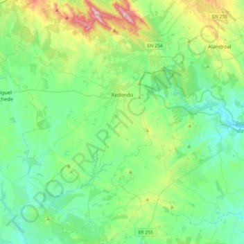
Name: Redondo topographic map, elevation, terrain.
Location: Redondo, Évora, Portugal (38.47553 -7.72566 38.75513 -7.48909)
Average elevation: 876 ft
Minimum elevation: 499 ft
Maximum elevation: 2,119 ft
Make a donation
Gear up for your next adventure:
As an Amazon Associate, this site earns from qualifying purchases at no extra cost to you.
Other topographic maps
Click on a map to view its topography, its elevation and its terrain.