Geolocate

Aguadahan topographic map

Click on the map to display elevation.

About this map

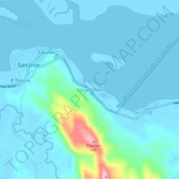
Name: Aguadahan topographic map, elevation, terrain.

Location: Aguadahan, Northern Samar, Eastern Visayas, 6402, Philippines (12.50458 124.48178 12.54458 124.52178)

Average elevation: 62 ft

Minimum elevation: -10 ft

Maximum elevation: 561 ft

Other topographic maps

Click on a map to view its topography, its elevation and its terrain.

Biri

Philippines > Northern Samar

Average elevation: 3 ft

Tarnate

Philippines > Northern Samar > San Vicente

Average elevation: 89 ft

Cagnipa Island

Philippines > Northern Samar > Biri > Santo Niño

Average elevation: 16 ft

Sitio Rabbit

Philippines > Northern Samar > Victoria

Average elevation: 89 ft

Capul

Philippines > Northern Samar

Average elevation: 16 ft

Capul Island

Philippines > Northern Samar > Capul

Average elevation: 46 ft

Palanit

Philippines > Northern Samar

Average elevation: 171 ft

Cagnipa Island

Philippines > Northern Samar > Biri > Santo Niño

Average elevation: 16 ft

Catubig River

Philippines > Northern Samar

Average elevation: 125 ft

Catarman

Philippines > Northern Samar

Average elevation: 164 ft

Catarman

Philippines > Northern Samar

Average elevation: 167 ft

Catarman

Philippines > Northern Samar

Average elevation: 167 ft

Gear up for your next adventure:

🎒Outdoor Daypacks - Lightweight backpacks designed for carrying maps and essential gear
📶Satellite Messenger - Communication device off‑grid
🥇GPS Hiking Watch - Multi‑sport GPS watch with navigation and trail tracking
🪶Camp Gear Gift Set - Perfect gift bundle for outdoor fans
🔌USB Car Charger - Car charger for on‑the‑go power needs

As an Amazon Associate, this site earns from qualifying purchases at no extra cost to you.