Geolocate

Kasha topographic map

Click on the map to display elevation.

About this map

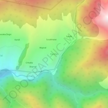
Name: Kasha topographic map, elevation, terrain.

Location: Kasha, Rampur, Shimla, Himachal Pradesh, India (31.38864 77.81565 31.42864 77.85565)

Average elevation: 8,999 ft

Minimum elevation: 6,440 ft

Maximum elevation: 12,592 ft

Other topographic maps

Click on a map to view its topography, its elevation and its terrain.

Rampur

India > Himachal Pradesh > Rampur

Average elevation: 9,662 ft

Gear up for your next adventure:

🚁Photography Drones - Capture stunning aerial views of landforms and topography
📌Outdoor GPS Map App - Apps and devices for digital topographic navigation
📻Weather Alert Radios - Stay informed of storm risks while off-the-grid
📷Action Cameras - Rugged cameras to document your journeys across rugged terrain
🥘Titanium Cookware - Durable, featherlight pots and pans for backpacking

As an Amazon Associate, this site earns from qualifying purchases at no extra cost to you.