Geolocate

Rampur topographic map

Click on the map to display elevation.

About this map

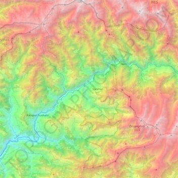
Name: Rampur topographic map, elevation, terrain.

Location: Rampur, Shimla, Himachal Pradesh, India (31.30397 77.52160 31.71404 77.95398)

Average elevation: 9,662 ft

Minimum elevation: 2,759 ft

Maximum elevation: 18,468 ft

Other topographic maps

Click on a map to view its topography, its elevation and its terrain.

Kasha

India > Himachal Pradesh > Rampur

Average elevation: 8,999 ft

Badain

India > Himachal Pradesh > Rampur > Tikar

Average elevation: 8,474 ft

Gear up for your next adventure:

🔥Plasma Lighters - Windproof lighters that work in any weather condition
📱Heavy-Duty Phone Cases - Drop-proof and waterproof protection for outdoor navigation
🧺Microfiber Travel Towels - Compact and fast-drying towels for trail use
Solar GPS Watches - Advanced multisport watches with built-in topographic maps
🪶Fire Starter Kit - Reliable fire starter for survival and camping

As an Amazon Associate, this site earns from qualifying purchases at no extra cost to you.