Geolocate

Hurghada topographic map

Click on the map to display elevation.

About this map

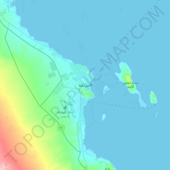
Name: Hurghada topographic map, elevation, terrain.

Location: Hurghada, Red Sea, 84512, Egypt (27.06256 33.67071 27.38256 33.99071)

Average elevation: 105 ft

Minimum elevation: -10 ft

Maximum elevation: 1,053 ft

Other topographic maps

Click on a map to view its topography, its elevation and its terrain.

Gulf of Suez

Egypt > Red Sea

Average elevation: 1,578 ft

Al Hadaba

Egypt > Red Sea

Average elevation: 135 ft

Al Hadaba

Egypt > Red Sea

Average elevation: 135 ft

Marsa Alam City

Egypt > Red Sea

Average elevation: 62 ft

Industrial Area

Egypt > Red Sea

Average elevation: 125 ft

Gulf of Suez

Egypt > Red Sea

Average elevation: 1,578 ft

Geziret Tubya

Egypt > Red Sea > Safaja

Average elevation: 0 ft

Wadi Gemal

Egypt > Red Sea

Average elevation: 1,227 ft

Safaja

Egypt > Red Sea

Average elevation: 3 ft

Gamsha

Egypt > Red Sea

Average elevation: 154 ft

Industrial Area

Egypt > Red Sea

Average elevation: 125 ft

Al Ahia'

Egypt > Red Sea

Average elevation: 52 ft

Al Qusair City

Egypt > Red Sea

Average elevation: 154 ft

Fresh water pool, cold

Egypt > Red Sea > Al Qusair City

Average elevation: 26 ft

Gear up for your next adventure:

👓Polarized Sunglasses - Outdoor sunglasses for glare reduction
💧Water Filtration Bottles - Safely drink from streams and lakes while exploring
🎒Gear Packing Cubes - Organize your backpack efficiently
🪑Ultralight Camp Chairs - Portable seating for resting after a long day of mapping
🔋Solar Power Banks - Keep your GPS and phone charged in remote wilderness areas

As an Amazon Associate, this site earns from qualifying purchases at no extra cost to you.