
Al Ahia' topographic map
Click on the map to display elevation.
About this map
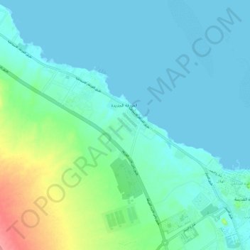
Name: Al Ahia' topographic map, elevation, terrain.
Location: Al Ahia', Red Sea, Egypt (27.23181 33.69175 27.32882 33.80907)
Average elevation: 52 ft
Minimum elevation: -3 ft
Maximum elevation: 279 ft
Other topographic maps
Click on a map to view its topography, its elevation and its terrain.
Gabal Elba
In the higher-elevation mist zone, species of acacia, Moringa and Gabal Elba dragon tree (Dracaena ombet) form the woodland tree canopy, with ferns, mosses and succulents in the understory. The mountain intercepts moisture-bearing winds from the northeast, and the northern and northeastern slopes are more…
Average elevation: 3,294 ft