Geolocate

Ravenna topographic map

Click on the map to display elevation.

About this map

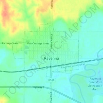
Name: Ravenna topographic map, elevation, terrain.

Location: Ravenna, Buffalo County, Nebraska, United States (41.01966 -98.92622 41.03463 -98.90310)

Average elevation: 2,024 ft

Minimum elevation: 1,978 ft

Maximum elevation: 2,119 ft

Buffalo County trails, hiking, mountain biking, running and outdoor activities

Other topographic maps

Click on a map to view its topography, its elevation and its terrain.

Glenwood Park

United States > Nebraska > Buffalo County

Average elevation: 2,169 ft

wood

United States > Nebraska > Buffalo County

Average elevation: 2,310 ft

Denman

United States > Nebraska > Buffalo County

Average elevation: 2,018 ft

Denman

United States > Nebraska > Buffalo County

Average elevation: 2,018 ft

Gear up for your next adventure:

🪶Multi‑Purpose Knife - Useful blade for camp and trail
🥾Hiking Shoes - Durable and comfortable shoes for trail hiking
🥘Titanium Cookware - Durable, featherlight pots and pans for backpacking
🧭Hiking Compass - Precision compass for reliable navigation in the wilderness
🌧️Backpack Rain Cover - Keep gear dry in wet weather

As an Amazon Associate, this site earns from qualifying purchases at no extra cost to you.