
Villianur Taluk topographic map
Interactive map
Click on the map to display elevation.
About this map
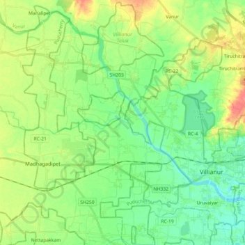
Name: Villianur Taluk topographic map, elevation, terrain.
Location: Villianur Taluk, Puducherry district, Puducherry, India (11.86209 79.61685 12.03481 79.79580)
Average elevation: 69 ft
Minimum elevation: 3 ft
Maximum elevation: 187 ft
Other topographic maps
Click on a map to view its topography, its elevation and its terrain.
Veerampattinam
India > Puducherry > Puducherry Taluk
Veerampattinam, Puducherry Taluk, Puducherry District, Puducherry, 605004, India
Average elevation: 10 ft
Puducherry
India > Puducherry > Puducherry Taluk
Puducherry, Puducherry Taluk, Puducherry District, Puducherry, 605001, India
Average elevation: 33 ft
moolakulam
India > Puducherry > Ozhukarai Taluk > Oulgaret
moolakulam, Mettupalayam, Oulgaret, Ozhukarai Taluk, Puducherry district, Puducherry, 605010, India
Average elevation: 39 ft
Mahe
India > Puducherry > Mahe Taluk
Mahe, Mahe Taluk, Mahe district, Puducherry, 673310, India
Average elevation: 33 ft
Bahour Taluk
Bahour Taluk, Puducherry District, Puducherry, India
Average elevation: 23 ft
Oulgaret
India > Puducherry > Ozhukarai Taluk
Oulgaret, Ozhukarai Taluk, Puducherry District, Puducherry, 605005, India
Average elevation: 59 ft
Kalapet
India > Puducherry > Ozhukarai Taluk
Kalapet, Ozhukarai Taluk, Puducherry District, Puducherry, 605014, India
Average elevation: 46 ft
Ozhukarai Taluk
Ozhukarai Taluk, Puducherry district, Puducherry, India
Average elevation: 75 ft
Oussudu WLS
Oussudu WLS, Vazhudavoor Road, BSNL Staff Quarters, Mettupalayam, Villianur Taluk, Puducherry district, Puducherry, 605010, India
Average elevation: 43 ft
Thirunallar
India > Puducherry > Thirunallar Taluk > Thirunallar
Thirunallar, Thirunallar Taluk, Karaikal district, Puducherry, 609607, India
Average elevation: 13 ft
Karaikal
India > Puducherry > Karaikal Taluk
Karaikal, Karaikal Taluk, Karaikal district, Puducherry, 609602, India
Average elevation: 10 ft
Yanam
India > Puducherry > Yanam Taluk
Yanam, Yanam Taluk, Yanam District, Puducherry, 533464, India
Average elevation: 16 ft
Bahour
India > Puducherry > Bahour
Bahour, Puducherry district, Puducherry, 607006, India
Average elevation: 30 ft
Villianur
India > Puducherry > Villianur
Villianur, Puducherry district, Puducherry, 605110, India
Average elevation: 43 ft